
Cllr Phil Davies: “it’s our hope that we won’t have to ideally develop any part of the greenbelt”
Please accept YouTube cookies to play this video. By accepting you will be accessing content from YouTube, a service provided by an external third party.
If you accept this notice, your choice will be saved and the page will refresh.
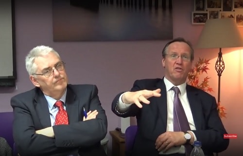
Yesterday evening at a public meeting of the Birkenhead Constituency Committee I asked the question below of Cllr Phil Davies (Leader of Wirral Council). I include Cllr Phil Davies’ answer below my question or you can watch him answer my question in the video above.
The formula for calculating the minimum annual local housing need on which the current Local Plan consultation is based is published here https://assets.publishing.service.gov.uk/government/uploads/system/uploads/attachment_data/file/728247/How_is_a_minimum_annual_local_housing_need_figure_calculated_using_the_standard_method.pdf .
The formula states “Taking the most recent household projections”.
On 23rd January 2017 responsibility for publishing the household projections moved from the Ministry of Housing, Communities and Local Government to the Office of National Statistics, as you can read for yourself in the grey box on this page about the household projections (which is also hyperlinked from the formula) here https://www.gov.uk/government/collections/household-projections.
Therefore the household projection figures recently published by the Office of National Statistics are the most recent household projections and therefore the ones that should be used for the Local Plan.
Could you therefore please answer:-
a) after the publication of the new household projection figures recently by the ONS why the 6 week Local Plan consultation on the old figures wasn’t abandoned,
b) why there is a report in the Wirral Globe today of Cllr Phil Davies writing to the Secretary of State for permission (which appears not to be required as the formula refers to the most recent figures) to use the new ONS figures,
c) due to the substantial drop in the household projection figures when the review of policies (that’s a legal requirement stemming from the change in household projection figures) which would be likely to be carried out
and
d) whether the review referred to in c) will result in a further 6 week consultation on the Local Plan using the most recent ONS figures?
Thanks.
Cllr Phil Davies said, “Well I know we’re going to give you a formal written answer, but the gist of it is as you say John that the ONS have published revised figures, and you do have to get the agreement of the government to use the new figures so we have written to get that permission and we’re waiting for that response, I hope we can.
We do need to do, the consultation won’t be affected because it’s a, it’s a legal part of the requirements as part of the Local Plan and particularly now the numbers have been reduced, it actually gives elected Members more choice because hopefully it’s our hope that we won’t have to ideally develop any part of the greenbelt.
If the figure had gone up, we would have had to have done a new consultation because we would have to identify additional greenbelt land, but because the number’s come down that’s not necessary, so it won’t require a new consultation and I think just a final thing to say is you know it’s obviously two things have been driving this one is the headline figure and it’s great news that’s come down.
There are rumours that the government will add houses on top of that because the new ONS figures don’t get you to the 300,000 that the government want to build but we await a response from the Secretary of State and the other thing obviously that we will now also have to do is even greater priority given to hopefully being able to deliver our new housing targets through brownfield building on brownfield sites and we are still awaiting a response from a number of key landholders about this, most noticeably Peel Holdings to make sure we have got the evidence to back up their figure of 6,450 houses on Wirral Waters that they say they’re going to develop.
But that has to be, all this has to be evidence based because it has to be able to satisfy a government inspector, a local planning inspector. So the consultation process will go on and the aim is still to bring a report to Cabinet in December with recommendations. So that’s the gist of the reply you’ll get in writing.”
If you click on any of the buttons below, you’ll be doing me a favour by sharing this article with other people.
Why should we believe a word that comes out of the mouth of a liar?
One who will be dumped out of office in May next year if the money wasted on his fraudulent, touchy-feely election campaign fails to turn the tide of anger and resentment that has been building for many years.
Thanks for your comment Paul.
My view is that it’s the role of the press to report on what politicians do, say and decide. Then when it comes around to election time and a politician stands for re-election, hopefully then the voters can make an informed choice.
That of course depends on reasonably high levels of adult literacy among the population. There are parts of Wirral where adult literacy rates are shockingly low!
I was at a meeting last week held by Wirral Green Belt Alliance and an independent Planning Consultant has been hired to help us assist with the review of the Local Plan. To be brief, we learned that any Local Authority who resides over Green Belt land MUST by law, even if there are enough brownfield sites to cover housing quotas for the life of the Local Plan, include a portion of that Green Belt in the Plan identified as available for release under ‘Very Special Circumstances’. If they do not include a portion of their Green Belt, however small (or large), then the Secretary of State will be obliged to return the Local Plan as incomplete. So either way you look at it, WBC have to include some of the Green Belt potentialy for development under ‘VSC’. The way they have gone about it is of course, typical of their shambolic approach, seemingly relying on 1 man to do the research and answer the questions. Bizarrely, we are still wondering why the Green Belt land targeted for the golf resort was not included in their map of Green Belt sites for consideration, when there are 160 homes penciled in on the development! So the fight for the public now is to identify the ‘best’ Green Belt to sacrifice for damage limitation and hope the brownfield figures are enough to satisfy building targets in the Local Plan for the next 5 years. Hopefully there won’t be a need to build on whatever Green Belt eventually makes its way into the Local Plan, but this will depend on the brownfield sites having a quick delivery in the next 5 years and meeting the quotas.
Thanks for your comment.
My own view of the situation conflicts with the advice you refer to from the planning consultant.
The reason for that view of mine is that one of the legal requirements placed on Local Plans (or “development plan documents”) as referred to in the legislation is that the Local Plan must include policies that contribute to the mitigation of and adaption to climate change (Planning and Compulsory Purchase Act 2002, s.19(1A)).
Models of climate change predict greater rainfall and Wirral already has a problem with flooding. The greenbelt helps with mitigating flooding, but developing it means rainfall instead of being soaked up by the earth would run off the hard surfaces of the development making flooding worse and therefore a Local Plan that earmarked parts of the existing greenbelt for development could be seen as not contributing to mitigating or adapting to climate change.
The situation at present is that planning applications can be made for sites in the greenbelt, but as approving them falls outside of policy that the decision has to be made by Wirral Council’s Planning Committee. If they decide that special circumstances apply and then approval of the application is delayed whilst the Secretary of State decides whether or not to call in the decision. As was seen with the Saughall Massie fire station planning application.
I don’t understand why the planning consultant you referred to states that the existing greenbelt boundaries have to change otherwise the Local Plan would be rejected.
Moving to your points about Hoylake Golf Resort, there are concerns that the large area it covers if developed would lead to flooding not just on the site itself but also of the surrounding areas.
However my view as to why the Hoylake Golf Resort site wasn’t included to be removed from the greenbelt was that when (or if) a planning application is submitted for it then the political view is that sufficient special circumstances can be put forward to counter arguments about development in the greenbelt. Whether a future Planning Committee will agree with such arguments though is another matter.
I take on board the legislation Re climate change, but she is working on from historical cases which have been rejected because the Local Authority have produced brownfield only sites to deliver housing quotas. Perhaps, it is the situation that the cases she was referring to were deemed not to have flooding issues should their Green Belt ever be used for development – this I do not know. But, we were all assured that it is Government policy to reject any Local Plans which do not include a quota of Green Belt (should it lie within the Local Authority’s care) in their sites.
She said any such Green Belt development on sites identified in an accepted Local Plan would still have to meet VSC (we know how that works with the WBC Planning Committee who seemingly accepted Dan Stephens’ ‘response times’ argument without much question on a majority level). She also referenced NPPF Paragraph 90:
“A local planning authority should regard the construction of new buildings as inappropriate in Green Belt. Exceptions to this are:-
limited infilling in villages, and limited affordable housing for local community needs under policies set out in the Local Plan”
David Ball has already identified such infill in the Irby/Pensby area.
Maybe in Wirral’s case, the legislation in S.19 F2 (1A) may be able to be argued in Wirral’s favour, but will our Council actively seek to use this as an argument not to include a Green Belt quota, however small?
It seems that a quota for potential development in Green Belt is in the first instance, a mandatory requirement for inclusion in a Local Plan from an Authority such as Wirral and her experience suggests we will have to accept this, though I will make the point about the climate change Legislation.
On a final point, the consultant we have hired is regularly contracted by Lancashire CPRE and was a Planning Officer at Manchester City Council so her experience and background with Green Belt planning issues is fit for purpose, having played both ‘poacher’ and ‘gamekeeper’.
My first point is that legislation, government policies and requirements on Local Plans changes over time with the recent publication of the ONS housing projections as an example of that.
As you mentioned Hoylake Golf Resort, in my reply I was referring to new development in what people generally view as the greenbelt rather than infilling of villages that are in the greenbelt.
In the legislation I linked to in the earlier reply, one of the other requirements is, “In preparing a local development document the local planning authority must have regard to— (a) national policies and advice contained in guidance issued by the Secretary of State;”
The most recent National Planning Policy Framework (published this summer) at paragraphs 136-141 states,
“136. Once established, Green Belt boundaries should only be altered where exceptional circumstances are fully evidenced and justified, through the preparation or updating of plans. Strategic policies should establish the need for any changes to Green Belt boundaries, having regard to their intended permanence in the long term, so they can endure beyond the plan period.Where a need for changes to Green Belt boundaries has been established through strategic policies, detailed amendments to those boundaries may be made through non-strategic policies, including neighbourhood plans.
137. Before concluding that exceptional circumstances exist to justify changes to Green Belt boundaries, the strategic policy-making authority should be able to demonstrate that it has examined fully all other reasonable options for meeting its identified need for development. This will be assessed through the examination of its strategic policies, which will take into account the preceding paragraph, and whether the strategy:
a) makes as much use as possible of suitable brownfield sites and underutilised land;
b) optimises the density of development in line with the policies in chapter 11 of this Framework, including whether policies promote a significant uplift in minimum density standards in town and city centres and other locations well served by public transport; and
c) has been informed by discussions with neighbouring authorities about whether they could accommodate some of the identified need for development, as demonstrated through the statement of common ground.
138. When drawing up or reviewing Green Belt boundaries,the need to promote sustainable patterns of development should be taken into account. Strategic policy-making authorities should consider the consequences for sustainable development of channelling development towards urban areas inside the Green Belt boundary, towards towns and villages inset within the Green Belt or towards locations beyond the outer Green Belt boundary.Where it has been concluded that it is necessary to release Green Belt land for development, plans should give first consideration to land which has been previously-developed and/or is well-served by public transport. They should also set out ways in which the impact of removing land from the Green Belt can be offset through compensatory improvements to the environmental quality and accessibility of remaining Green Belt land.
139. When defining Green Belt boundaries, plans should:
a) ensure consistency with the development plan’s strategy for meeting identified requirements for sustainable development;
b) not include land which it is unnecessary to keep permanently open;
c) where necessary, identify areas of safeguarded land between the urban area and the Green Belt, in order to meet longer-term development needs stretching well beyond the plan period;
d) make clear that the safeguarded land is not allocated for development at the present time.Planning permission for the permanent development of safeguarded land should only be granted following an update to a plan which proposes the development;
e) be able to demonstrate that Green Belt boundaries will not need to be altered at the end of the plan period; and
f) define boundaries clearly, using physical features that are readily recognisable and likely to be permanent.
140. If it is necessary to restrict development in a village primarily because of the important contribution which the open character of the village makes to the openness of the Green Belt, the village should be included in the Green Belt. If, however, the character of the village needs to be protected for other reasons, other means should be used, such as conservation area or normal development management policies, and the village should be excluded from the Green Belt.
141. Once Green Belts have been defined, local planning authorities should plan positively to enhance their beneficial use, such as looking for opportunities to provide access; to provide opportunities for outdoor sport and recreation; to retain and enhance landscapes, visual amenity and biodiversity; or to improve damaged and derelict land.”
I think my general point was that with Wirral Council having dragged its feet over production of a Local Plan and the Local Plan processes taking a few years before adoption that over that time requirements on producing a Local Plan change (for example the change to the housing projections) and therefore experience based on Local Plans in the past isn’t necessarily the way things have to be done now.
That’s quite a comprehensive set of guidelines which should offer all the protection needed.
A couple of noticeable pieces of terminology:
“Strategic policies should establish the need for any changes to Green Belt boundaries,”
Maybe WBC believe they are in the process of making “strategic policies” in order to change Green Belt boundaries? David Ball is already arguing that Pensby and Irby are one settlement and suggesting a justification for infill.
Point 141 looks like an arguable justification for Phil’s golf resort wet dream – but not housing. But he needs the housing aspect to give a quick return on the project to keep the Council’s ‘preferred partner’ sweet because the golf thing won’t set the world on fire overnight. Housing is the key to the project being viable.
But with no now justification to need to redraw the greenbelt boundaries to meet the revised housing targets, would a planning inspector reject a Local Plan as unsound if Wirral Council tried to change the existing greenbelt boundaries?
I’m forwarding the whole NPPF July 2018 document to the Green Belt Alliance Committee and referring them to S.13. It really goes against everything WBC were originally using as their ‘scare tactics’. Are they seeking to be fake ’11th hour saviours of the Green Belt’ do you think?
When the Local Plan consultation is over it comes back to Cabinet in December.
The policy on the Local Plan voted on 28 votes to 26 at the special Council meeting last month can be read on Wirral Council’s website here.
Despite what was said by Cllr Phil Davies at the Birkenhead Constituency Committee last week, I’m pretty sure I remember him at the Cabinet meeting on Monday morning he referred to the ONS figures as housing targets (without any caveat or qualification).